The Nile and the Geography of Ancient Egypt

Home | Category: Themes, Early History, Archaeology

GEOGRAPHY OF EGYPT

20120215-293px-Ancient_Egypt_map-en.svg.png Bordered by the Red Sea and Israel to the east, Sudan to the south, Libya to the west and the Mediterranean Sea to the north, modern Egypt is a 386,650 square miles in area, or roughly the twice the size of California. Only 2.6 percent of the country is good for agriculture (compared to 21 percent in the U.S.) and most of this land is located in the Nile Delta and along the Nile Valley. There are no forests in Egypt. There are some barren mountains in the southern Sinai and running parallel to the Red Sea. Egypt’s deserts have little or no vegetation and are very hot.

Modern Egypt is roughly square in shape, measuring 640 miles (1040 kilometers) from north to south, and 600 miles (980 kilometers) from east to west in the north and 760 miles (1240 kilometers) from east to west in the south. Upper Egypt refers to southern Egypt, specifically to the Nile Valley south of Cairo. Lower Egypt refers to northern Egypt, usually the Nile Delta, north of Cairo. The regions are so named because Upper Egypt is along the upriver section of the Nile and Lower Egypt is located on the down river section of the Nile.

The Nile Valley is 930 miles (1510 kilometers) long and varies in width from two to 10 miles (three to 16 kilometers). Stretching the length of Egypt from north to south and occupying a depression around the Nile River, it occupies 3 percent of Egypt's land but is home to 96 percent of its people. The majority of Egyptians live around the Nile. For them the desert is almost as alien an environment as snow-capped mountains.

The fertile Nile Delta, between Cairo and the Mediterranean Sea, is one of the world's most intensely cultivated piece of land. It covers 6,000 square miles (15,500 square kilometers) and is about a 100 miles (160 kilometers) in length from north to south and 150 miles (240 kilometers) wide at its widest point.

To the west of the Nile is the Western Desert. Covering 68 percent of Egypt, it is mostly a flat, sand- and gravel-covered, barren wasteland that rarely exceeds 600 feet (200 meters) above sea level. It extends from the Nile Valley to Libya and from the Mediterranean Sea to Sudan. Most of its people live in and around five major oases. To the east of Nile is the Eastern Desert, which is made up large of a plateau extending from the Nile to the Red Sea, with some hills and a ridge of mountains on the Red Sea side. Most of the people in this region live along the Red Sea.

The Sinai peninsula is a triangular piece of land between the Gulf of Suez and the Gulf of Aqaba (branches of the Red Sea) and the Mediterranean and Israel. Egypt's highest peak, 8,668-foot-high (2643 meter-high) Mount Catherine, is located on the Sinai. Nearby is 7,497-foot-high (2285 meter-high) Mt. Sinai. The presence of charcoal at sites in Giza is viewed as evidence that trees once grew around there. Modern Egypt has about 1,800 miles (2930 kilometers) of coastline: 600 miles (980 kilometers) along the Mediterranean Sea and 1,200 miles (1950 kilometers) along the Red Sea. The Suez Canal is located to the west of the Sinai. It connects the Mediterranean Sea and the Gulf of Suez (the Red Sea).

Websites on Ancient Egypt: UCLA Encyclopedia of Egyptology, escholarship.org ; Internet Ancient History Sourcebook: Egypt sourcebooks.fordham.edu ; Discovering Egypt discoveringegypt.com; BBC History: Egyptians bbc.co.uk/history/ancient/egyptians ; Ancient History Encyclopedia on Egypt ancient.eu/egypt; Digital Egypt for Universities. Scholarly treatment with broad coverage and cross references (internal and external). Artifacts used extensively to illustrate topics. ucl.ac.uk/museums-static/digitalegypt ; British Museum: Ancient Egypt ancientegypt.co.uk; Egypt’s Golden Empire pbs.org/empires/egypt; Metropolitan Museum of Art www.metmuseum.org ; Oriental Institute Ancient Egypt (Egypt and Sudan) Projects ; Egyptian Antiquities at the Louvre in Paris louvre.fr/en/departments/egyptian-antiquities; KMT: A Modern Journal of Ancient Egypt kmtjournal.com; Ancient Egypt Magazine ancientegyptmagazine.co.uk; Egypt Exploration Society ees.ac.uk ; Amarna Project amarnaproject.com; Egyptian Study Society, Denver egyptianstudysociety.com; The Ancient Egypt Site ancient-egypt.org; Abzu: Guide to Resources for the Study of the Ancient Near East etana.org; Egyptology Resources fitzmuseum.cam.ac.uk

Herodotus on the Geography of Egypt


Herodotus

Herodotus wrote in Book 2 of “Histories”: “Beyond and above Heliopolis, Egypt is a narrow land. For it is bounded on the one side by the mountains of Arabia, which run north to south, always running south towards the sea called the Red Sea. In these mountains are the quarries that were hewn out for making the pyramids at Memphis. This way, then, the mountains run, and end in the places of which I have spoken; their greatest width from east to west, as I learned by inquiry, is a two months' journey, and their easternmost boundaries yield frankincense. Such are these mountains. On the side of Libya, Egypt is bounded by another range of rocky mountains among which are the pyramids; these are all covered with sand, and run in the same direction as those Arabian hills that run southward. Beyond Heliopolis, there is no great distance—in Egypt, that is:8 the narrow land has a length of only fourteen days' journey up the river. Between the aforesaid mountain ranges, the land is level, and where the plain is narrowest it seemed to me that there were no more than thirty miles between the Arabian mountains and those that are called Libyan. Beyond this Egypt is a wide land again. Such is the nature of this country. 9. [Source: Herodotus, “The Histories”, Egypt after the Persian Invasion, Book 2, English translation by A. D. Godley. Cambridge. Harvard University Press. 1920, Tufts]

“From Heliopolis to Thebes is nine days' journey by river, and the distance is six hundred and eight miles, or eighty-one schoeni. This, then, is a full statement of all the distances in Egypt: the seaboard is four hundred and fifty miles long; and I will now declare the distance inland from the sea to Thebes : it is seven hundred and sixty-five miles. And between Thebes and the city called Elephantine there are two hundred and twenty-five miles. 10.

“The greater portion, then, of this country of which I have spoken was land deposited for the Egyptians as the priests told me, and I myself formed the same judgment; all that lies between the ranges of mountains above Memphis to which I have referred seemed to me to have once been a gulf of the sea, just as the country about Ilion and Teuthrania and Ephesus and the plain of the Maeander, to compare these small things with great. For of the rivers that brought down the stuff to make these lands, there is none worthy to be compared for greatness with even one of the mouths of the Nile, and the Nile has five mouths. There are also other rivers, not so great as the Nile, that have had great effects; I could rehearse their names, but principal among them is the Achelous, which, flowing through Acarnania and emptying into the sea, has already made half of the Echinades Islands mainland. 11.

Herodotus on the Red Sea and Arabia

Herodotus wrote in Book 2 of “Histories”: Now in Arabia, not far from Egypt, there is a gulf extending inland from the sea called Red9 , whose length and width are such as I shall show: in length, from its inner end out to the wide sea, it is a forty days' voyage for a ship rowed by oars; and in breadth, it is half a day's voyage at the widest. Every day the tides ebb and flow in it. I believe that where Egypt is now, there was once another such gulf; this extended from the northern sea towards Aethiopia, and the other, the Arabian gulf of which I shall speak, extended from the south towards Syria; the ends of these gulfs penetrated into the country near each other, and but a little space of land separated them. Now, if the Nile inclined to direct its current into this Arabian gulf, why should the latter not be silted up by it inside of twenty thousand years? In fact, I expect that it would be silted up inside of ten thousand years. Is it to be doubted, then, that in the ages before my birth a gulf even much greater than this should have been silted up by a river so great and so busy? 12. [Source: Herodotus, “The Histories”, Egypt after the Persian Invasion, Book 2, English translation by A. D. Godley. Cambridge. Harvard University Press. 1920, Tufts]

“As for Egypt, then, I credit those who say it, and myself very much believe it to be the case; for I have seen that Egypt projects into the sea beyond the neighboring land, and shells are exposed to view on the mountains, and things are coated with salt, so that even the pyramids show it, and the only sandy mountain in Egypt is that which is above Memphis; besides, Egypt is like neither the neighboring land of Arabia nor Libya, not even like Syria (for Syrians inhabit the seaboard of Arabia); it is a land of black and crumbling earth, as if it were alluvial deposit carried down the river from Aethiopia; but we know that the soil of Libya is redder and somewhat sandy, and Arabia and Syria are lands of clay and stones. 13.


Herodotus Map of Lower Egypt


Herodotus on Nile Delta and Upper and Lower Egypt

Herodotus wrote in Book 2 of “Histories”: “We leave the Ionians' opinion aside, and our own judgment about the matter is this: Egypt is all that country which is inhabited by Egyptians, just as Cilicia and Assyria are the countries inhabited by Cilicians and Assyrians, and we know of no boundary line (rightly so called) below Asia and Libya except the borders of the Egyptians. But if we follow the belief of the Greeks, we shall consider all Egypt commencing from the Cataracts and the city of Elephantine12 to be divided into two parts, and to claim both the names, the one a part of Libya and the other of Asia. For the Nile, beginning from the Cataracts, divides Egypt into two parts as it flows to the sea. Now, as far as the city Cercasorus the Nile flows in one channel, but after that it parts into three. [Source: Herodotus, “The Histories”, Egypt after the Persian Invasion, Book 2, English translation by A. D. Godley. Cambridge. Harvard University Press. 1920, Tufts]

“One of these, which is called the Pelusian mouth, flows east; the second flows west, and is called the Canobic mouth. But the direct channel of the Nile, when the river in its downward course reaches the apex of the Delta, flows thereafter clean through the middle of the Delta into the sea; in this is seen the greatest and most famous part of its waters, and it is called the Sebennytic mouth. There are also two channels which separate themselves from the Sebennytic and so flow into the sea: by name, the Saïtic and the Mendesian. The Bolbitine and Bucolic mouths are not natural but excavated channels. 18.

“The response of oracle of Ammon in fact bears witness to my opinion, that Egypt is of such an extent as I have argued; I learned this by inquiry after my judgment was already formed about Egypt. The men of the cities of Marea and Apis, in the part of Egypt bordering on Libya, believing themselves to be Libyans and not Egyptians, and disliking the injunction of the religious law that forbade them to eat cows' meat, sent to Ammon saying that they had no part of or lot with Egypt: for they lived (they said) outside the Delta and did not consent to the ways of its people, and they wished to be allowed to eat all foods. But the god forbade them: all the land, he said, watered by the Nile in its course was Egypt, and all who lived lower down than the city Elephantine and drank the river's water were Egyptians. Such was the oracle given to them. 19.

The Nile

The Nile in modern Egypt extends for 600 miles between Aswan in southern Egypt to the Mediterranean Sea. South of Aswan, breaking up the river and extending south Sudan, is 300-mile-long Lake Nasser, a reservoir created by the Aswan High Dam. The Nile is made up of the Blue Nile (originating in Ethiopia) and the White Nile (originating in Burundi in Central Africa) which combine to form the Nile in the Sudan. North of Cairo is the Nile Delta. Here the Nile splits several tributaries, the largest ones being the Rosseta


Lower Egypt

The Nile River is the longest river in the world as every school child knows. Extending for 4,145 miles from its source in the central African to the Mediterranean Sea, its drainage area encompasses nearly a tenth of Africa and covers an estimated 1,293,000 square miles in nine countries. According to the Guinness Book of Records, if the Pará estuary is counted, the Amazon is 4,195 miles long, which make it longer mile Nile River, which lost a few miles after the construction the Aswan Dam. The flow of the Amazon is 60 times greater than the flow of the Nile.

The Nile begins in places with abundant rain but passes through areas that are dry and barren. In these places the Nile is like a long oasis bringing water, food, and life to places that otherwise would have none of these things. An ancient Egyptian hymn goes: “Hail to you, O Nile, rushing from the earth and giving life to Egypt.” Without the Nile, Ancient Egypt may never have become the great civilization it became nor lasted as long as it did.

Sailors say the traffic on the Nile can be almost as bad as traffic on the streets of Cairo. On the Nile delta most boats move only at night because the drawbridges are only open after dark. One journalist wrote, "When a bridge finally opened, the effect was of dynamite on a log jam, but with a difference: As the span lifted, everything rushed through — to meet headlong with a jam coming the other way. In the blackness of the river the result was bedlam.♬

Nile River and History

The present Nile is only about 30,000 years old. It was preceded by at least four other versions of the river that were nourished when the Sahara was not a desert. In 1958, scientists using radioisotopes tracked a crypto-river flowing under the Nile with an annual flow of 20 trillion cubic feet — six times greater than the Nile itself.

The ancient Egyptians regulated their lives according to flooding cycles of the Nile. They relied on the flooding to fertilize their farms but also suffered when high water carried away their homes and property. The ancient Egyptians believed the Nile was sacred, partly because they had no idea how the river's life-giving floodwaters could mysteriously appear every year out of a barren desert. They didn't know where the river started, and they assumed the water had to be a gift from the gods.

According to Egyptian mythology, the Nile divided the world in two, while the Nile itself was compared to a lotus: with the Nile as the flower, the oasis of Al-Faiyum as the bud; and the Nile Valley as the stem. The Greek historian Herodotus described Egypt as the "the gift of the Nile."

Millennia of floods, droughts and silt deposits have shifted the Nile eastward. Memphis, the seat of the pharaohs, literally, grew in the direction of the Nile as it moved. In the 2nd century the Greek geographer Ptolemy suggested that Nile originated in the mythical Mountain of the Moon in Africa, but no one got close to the real source until the end of the 19th century when British explorer John Speke suggested than it started in Lake Victoria. Later expeditions showed he was close — the actual source is a stream in Burundi that empties into the Kagera River, which, after 250 miles, flows into Lake Victoria.

The construction of the Aswan Dam dramatically altered the character of the Nile in Egypt. Lake Nasser, which was produced by the dam. submerged the second cataract and turned the southern section of the river in Egypt into a 300-mile long reservoir. The dam brought an end to the annual floods but it has also robbed the land of the fertile silt deposited on the farm land each year by the floods.

Nile Route

20120215-Nubia_NASA-WW_places_german.jpg
The Nile in central Nubia (Sudan)
Rains that fall in nine modern nations — Egypt, Sudan, Ethiopia, Tanzania, Uganda, Kenya, the Democratic Republic of the Congo (Zaire), Burundi and Rwanda, more than 10 percent of Africa — drain into the Nile. About 85 percent of headwater are in Ethiopia.

The Nile is made up of three major tributaries — the White Nile, the Blue Nile and the Atbara. The source of the White Nile a spring in Burundi that feeds the Kagara River in Rwanda, which in turn flows into Lake Victoria. The source of the Blue Nile is near Lake Tana, Ethiopia. The Atbara River contributes one-fifth of the Nile — s volume during floods. The last major tributary of the Nile, it originates in the highlands of northwestern Ethiopia, flows through Sudan and joins the Nile 200 miles upstream from Khartoum.

The Blue Nile begins at Lake Tana, a large Rift Valley lake in central Ethiopia surrounded by Coptic monasteries. After tumbling over Blue Nile Falls, the river winds through a steep gorge in the Central Ethiopian Plateau that is a mile deep. The source of floodwaters in Egypt are the annual rains that fall on Ethiopia and empty into the Blue Nile and Atbara, Much of the fertile silt in the Nile is top soil that washes down from the Ethiopian highlands.

White Nile

The White Nile is the longest of the three Nile tributaries. It winds through Uganda and descends 1,700 feet between Lake Victoria and Lake Albert on the Zaire border. Along the way the White Nile flows though Muchinson Falls, where the river narrows from a width of a half a mile to a few hundred meters and then shots through 20-foot-channel like a foaming white "hydraulic explosion." The Albert Nile, which originates in the Ruwenzori mountains, flows into Lake Albert.

In the Bahr el Jebel region of the Sudan the river spreads out in vast unnavigable swamp filled with papyrus reeds and elephants grass. One British explorer called it a “horrible region of everlasting swamp.” The water moves so slowly in this 500 mile long region that half the river evaporates into the sky or seeps into the soil. The 225-mile Jonglei Canal was designed to reduce water loss from the evaporation and bring water to 400,000 acres of land. Construction was halted due to the civil war in the Sudan.
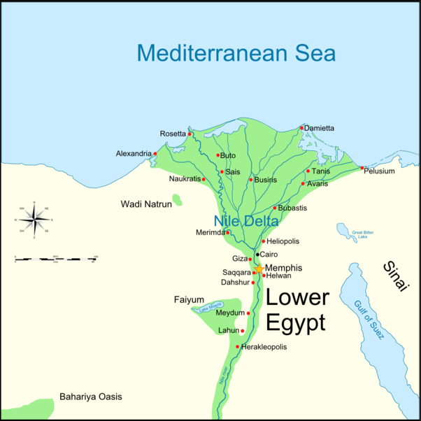
Nile After Khartoum

20120215-Temple_of_Dakkeh.jpg
Nile in southern Egypt
At Khartoum the roughly 2200 mile-long White Nile joins the 850-mile-long Blue Nile to form the Nile proper. The Nile is an important transportation route in Sudan. Waters from the Nile in this barren region are harnessed for irrigation.

North of Khartoum the Nile flows in a broad S-shaped pattern for 1,200 miles through the desert, where it is interrupted briefly by six cataracts (areas of rapids and granite outcroppings). Numbered in ascending order from north to south, the cataracts make the river unnavigable between Lake Nasser in southern Egypt and Khartoum in central Sudan.

Between the First Cataract, not far from Aswan, and Cairo the river is navigable but often times the river is so shallow that the only boats that can negotiate it are flat-bottomed fellucas. North of Cairo the river separates into scores of channels in the approximately 100-mile-wide Nile Delta.

The desert provided a natural barrier against invaders.

Oases provided dates, olives and wine.

Nile Valley

20120215-Pyramids_during_the_inundation.jpg The Nile Valley is a flat flood plain that follows the Nile over the length of Egypt from north to south. Described as a 600-mile-long oasis, it is 930 miles (if Lake Nasser is included) and averages two miles in width. It makes up only 3 percent of Egypt’s land but is home to 96 percent of Egypt’s population. In many places it is flanked by escarpments and cliffs. Many temples and tombs have been placed on top of these. The majority of Egyptians live around the Nile. For them the desert is almost as alien an environment as snow-capped mountains.

In Egypt the Nile flows through land that receives almost no rain. The river provides water for crops such as cotton, sugar, rice and is the life force for millions of people. When viewed from an airplane the Nile valley looks like a green ribbon surrounded by endless deserts. In some places the cultivated area is limited by escarpments. In other places where the land is flat and no escarpments are present irrigation has extended agricultural land outward from the river for miles.

Many of the people who live around the river live in villages that have been unchanged by the centuries. The residents dress in robes and turbans as their ancestors have centuries and till the soil and irrigate their crops using traditional methods.

According to Minnesota State University, Mankato: “The geography of Egypt is deeply important in understanding why the Egyptians centered their lives around the Nile. Both before and during the use of canal irrigation in Egypt, the Nile Valley could be separated into two parts, the River Basin or the flat alluvial (or black land soil), and the Red Land or red desert land. The River basin of the Nile was in sharp contrast to the rest of the land of Egypt and was rich with wild life and water fowl, depending on the waxing and waning cycles of the Nile. In contrast, the red desert was a flat dry area which was devoid of most life and water, regardless of any seasonal cycle.” [Source: Minnesota State University, Mankato, ethanholman.com]

Nile Delta

The Nile Delta is a flat expanse of extremely fertile land covered with green fields and laced with canals. Covering about 6,000 square miles, it has such a perfect triangular shape that the ancient Greeks coined the world "delta" to describe it because they were reminded of a Greek letter by the same name. The ancient Egyptians also had a major presence here. Some scholars believed that Menes I conquered Lower Egypt and unified Egypt to get his hands on the Delta. Jews believe that the delta was Goshen, the "house of bondage" where the Israelites labored for the pharaoh before they were led to the promised land by Moses.

20120215-fishing.jpg
fishing
The Nile Delta is about a 100 miles in length from north to south and 150 miles wide at its widest point. North of Cairo the Nile splits into several tributaries, the largest ones being the Rosseta and Damietta branches, which empty into the Mediterranean Sea near ports with the same names.

In many ways life on delta today has changed remarkably little since Biblical times. Most peasants still use cattle plows instead of tractors to cultivate their land. Water wheels and Archimedes screws are used instead of pumps to lift water from the Nile. However, more and more, traditional saqia irrigation wheels are being replaced by diesel pumps.

The Nile Delta is one of the world's most intensely cultivated piece of land. Almost every inch of the region cultivated. The land is divided into fields and canal chocked with hyciths and papyrus. There are cotton fields, rice paddies, wheat fields, grape arbors, and fields with leafy vegetables, beets, melons, broad beans, potatoes, and squashes. Of Egypt's 7.5 million acres of arable land, 6 million acres is in the Nile Delta.

Over a million people now live in the Nile Delta area, along with thousands of water buffalo, donkeys and thousands of migratory birds (up until 1980, 25 percent of all the wetlands in the Mediterranean was in the Nile Delta). The Egyptians that live in the delta area are known for their industriousness. [Source: Peter Theroux, National Geographic, January 1997]

Near Zagazig are the runs of Bubastis, one of the oldest ancient cities in Egypt and the center of an ancient cat cult. Some 40 miles northeast of Zagazig near the village of San el Hagar are the ruins of Tanis, where statues of pharaohs were stored and many scholars believe the Hebrews were enslaved. Rashid (40 miles east of Alexandria) is where the Rosetta St was found by Napoleon;s soldiers in 1799. It is located where the western Rosetta branch of the Nile empties into the Mediterranean.
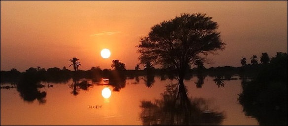
Nile Flooding

The water in the Nile is generally very shallow but goes through periods of flooding caused mostly by heavy rains in Africa, particularly in the Ethiopian highlands. First the White Nile floods, then the Blue Nile and its tributaries. The flood waters reach Egypt in late spring and rise through the summer until they reach their peak in September or October and then decline until November.

The water level of Nile fluctuates as much as 10 feet a year. Water levels are at their lowest around July when seasonal rains are late in Africa. Describing the flood season Herodotus wrote: “Only the towns remain above water, looking rather like the islands of the Aegean.” The Nile floods used to deposit as much as 20 million tons of silt on fields along the river every year. As the floods recede the water drains through the soil, leaching out the salts and carrying them off to the sea.

The Nile loses up to 95 percent of it water (compared to 1 percent of the Rhone), most of it for agriculture. The area around the Upper Nile receives only three to five millimeters of rain a year. In ancient times there was a system of dykes that diverted water into basins. When the river flooded water filled the basins. When the water left fertile silt was left behind. To get water to agriculture land a number of pumping stations have been built along the Nile.

Inundation of the Nile

According to Minnesota State University, Mankato: “The Nile in it's natural state goes through periods of inundation and relinquishment. The inundation of the Nile-a slightly unpredictable event-was the time of greatest fertility for Egypt. As the banks rose, the water would fill the man-made canals and canal basins and would water the crops for the coming year. However, if the inundation was even twenty inches above or below normal, it could have massive consequences upon the Egyptian agricultural economy. Even with this variability, the Egyptians were able to easily grow tree crops and vegetable gardens in the lower part of the Nile Valley, while at higher elevations, usually near levees, the Nile Valley was sparsely planted.” [Source: Minnesota State University, Mankato, ethanholman.com]


flooding of the Nile at sunset


According to Plumbing & Mechanical Magazine: “From ancient times, the rise and fall of the River Nile portended periods of famine or good fortune for the peoples of Egypt. Other than wells, the River Nile is the only source of water in the country. During an idyllic year, the flooding of the Nile would begin in July, and by September its receding waters would deposit a rich, black silt in its wake for farming. Before taming the river, however, the ancient Egyptians had to overcome the river’s peculiar problem. The Nile runs along an alluvial plain, the ebb and tide of the Nile corresponding to an annual movement of the ground. When the Nile is the lowest, the ground completely dries up. When it floods, the water seeps into the dry soil and causes the ground to rise as much as a foot or two like some bloated sponge. As the inundation subsides the ground settles again to its original dry level, but never settles evenly.” [Source: Plumbing & Mechanical Magazine, July 1989, theplumber.com]

John Baines of the University of Oxford wrote: “The Nile's annual inundation was relatively reliable, and the floodplain and Delta were very fertile, making Egyptian agriculture the most secure and productive in the Near East. When conditions were stable, food could be stored against scarcity. The situation, however, was not always favourable. High floods could be very destructive; sometimes growth was held back through crop failure due to poor floods; sometimes there was population loss through disease and other hazards. Contrary to modern practice, only one main crop was grown per year. [Source: John Baines, BBC, Professor of Egyptology at the University of Oxford, February 17, 2011 |::|]

“Crops could be planted after the inundation, which covered the Valley and Delta in August and September; they needed minimal watering and ripened from March to May. Management of the inundation in order to improve its coverage of the land and to regulate the period of flooding increased yields, while drainage and the accumulation of silt extended the fields. Vegetables grown in small plots needed irrigating all year from water carried by hand in pots, and from 1500 B.C. by artificial water-lifting devices. Some plants, such as date palms, whose crops ripened in the late summer, drew their water from the subsoil and needed no other watering. |::|

Harnessing the Nile to Create Ancient Egyptian Civilization

According to Plumbing & Mechanical Magazine: “The name Egypt means “Two Lands,” reflecting the two separate kingdoms of Upper and Lower prehistoric Egypt – Delta region in the north and a long length of sandstone and limestone in the south. In 3000 B.C., a single ruler, Menes, unified the entire land and set the stage for an impressive civilization that lasted 3,000 years. He began with the construction of basins to contain the flood water, digging canals and irrigation ditches to reclaim the marshy land. [Source: Plumbing & Mechanical Magazine, July 1989, theplumber.com /~/]

“From these earliest of times, so important was the cutting of a dam that the event was heralded by a royal ceremony. King Menes is credited with diverting the course of the Nile to build the city of Memphis on the site where the great river had run. By 2500 B. C., an extensive system of dikes, canals and sluices had developed. It remained in use until the Roman occupation, circa 30 B.C. – 641 A.D. For pure water, the Egyptians depended upon wells. Their prowess in divining hidden sources is shown in the “Well of Joseph,” constructed about 3000 B.C. near the Pyramids of Gizeh. Workers had to dig through 300 feet of solid rock to tap into the water.” /~/


Nile flood plain limits


John Baines of the University of Oxford wrote: “Throughout antiquity, Egypt's standing relied on its agricultural wealth and, therefore, on the Nile. Agriculture had not been the original basis of subsistence, but evolved, together with the land itself, during the millennia after the last Ice Age ended around 10,000 B.C., expanding greatly from about 4500 B.C. onward. [Source:John Baines, BBC, Professor of Egyptology at the University of Oxford, February 17, 2011 |::|]

By 3100 B.C. the Nile Valley and Delta had coalesced into a single entity that was the world's first large nation state. As well as providing the region's material potential, the Nile and other geographical features influenced political developments and were significant in the development of Egyptian thought. The land continued to develop and its population increased until Roman times. Important factors in this process were unity, political stability, and the expansion of the area of cultivated land. The harnessing of the Nile was crucial to growth.” |::|

“It is uncertain how early and by how much the inundation was regulated. By the Middle Kingdom (c.1975-1640 B.C.) basin irrigation, in which large sections of the floodplain were managed as single units, was well established, but it may not have been practised in the Old Kingdom (c.2575-2150 B.C.), when the great pyramids were built. The only area where there was major irrigation work before Graeco-Roman times was the Faiyum, a lakeside oasis to the west of the Nile. Here Middle Kingdom kings reclaimed land by controlling the water flow along a side river channel and directing it to irrigate extra land while lake water levels were lowered. Their scheme did not last. |::|

Nile and Life in Ancient Egypt

John Baines of the University of Oxford wrote: “The principal crops were cereals, emmer wheat for bread, and barley for beer. These diet staples were easily stored. Other vital plants were flax, which was used for products from rope to the finest linen cloth and was also exported, and papyrus, a swamp plant that may have been cultivated or gathered wild. Papyrus roots could be eaten, while the stems were used for making anything from boats and mats to the characteristic Egyptian writing material; this too was exported. A range of fruit and vegetables was cultivated. Meat from livestock was a minor part of the diet, but birds were hunted in the marshes and the Nile produced a great deal of fish, which was the main animal protein for most people. [Source: John Baines, BBC, Professor of Egyptology at the University of Oxford, February 17, 2011 |::|]

“These features are known from finds of plant and animal residues and from texts. The Egyptians also celebrated their world in the decoration of tombs. There we see many images of agriculture and animal husbandry, but the Nile itself is largely absent. Instead, the focus of watery scenes is on marshes where game was hunted and on small watercourses that were crossed by peasants and herders. Pictures in temples of major festivals and of the return of trading and transport expeditions that used large ships are the main representations that show the river explicitly. These scenes brought glory to the king, who commissioned the expeditions. |::|

“The shape of the land was significant in other ways. The Delta and its mouths posed obstacles to invaders. Travel into the desert or to Asia was altogether more difficult than movement within Egypt, where the ease of boat travel on the Nile was a major unifying force in such a long, thin country. In social terms, however, the river could also separate people. The image of a poor man was someone who had no boat, whom the more fortunate should ferry across. Dying was 'coming to land' on the other side, and the passage into the next world was a 'crossing'. |::|


Nile inundation


Influence of the Nile on the Ancient Egyptian World View

John Baines of the University of Oxford wrote: “The Nile and its inundation were basic to the Egyptian world-view. Unlike most peoples, the Egyptians oriented towards the south, from which the river came, so that the west was on their right-with the result that it was the 'good' side for passage into the next world. The year and calendar were adjusted to the Nile and the stars. New Year was in mid July, when the river began to rise for the inundation; this coincided approximately with the reappearance of the star Sirius (Egyptian Sothis) in the sky after 70 days' invisibility. Sothis provided the astronomical anchor for the 365 day calendar. The river defined three seasons of four months: 'Inundation' and 'Emergence' (November-March) when the land reappeared and could be cultivated, and 'Heat' or Harvest, when crops were gathered and the water was lowest. [Source: John Baines, BBC, Professor of Egyptology at the University of Oxford, February 17, 2011 |::|]

“In some ways, the Nile's fundamental importance for the sustaining of human life may be more obvious to us than it was to the ancient Egyptians. They thought of its regular flooding, so essential for the fertility of the land it ran through, as the natural state of affairs-so much so that they termed rain in other countries an 'inundation in the sky'. |::|

“In order to appreciate the Nile's position in antiquity, we should see it through ancient eyes, remembering the ancient distinctions between the divine and the human. The Egyptians had a relatively matter-of-fact attitude towards the river, whose inundations could sometimes cause destruction but were seen a beneficent moral force. Egyptian gods, by contrast, were seen as complex beings whose abode was outside the physical world of the land and river. It was left to the Greeks and Romans to make a god of the Nile, as they had of the other rivers of the world.” |::|

Impact of the Nile on Ancient Egyptian Political Thought

John Baines of the University of Oxford wrote: “The compactness of Egypt, focused on the Nile, favoured political unity, which brought both potential for exploiting the land's fertility and obligations for rulers. Kings controlled agricultural resources through ultimate ownership of land, taxation of its produce, administrative measures to ensure that it was cultivated, and compulsory labour. In return for control, they were responsible for storage and for provision against failures, so that they took upon themselves much that is achieved through cooperation in small societies. |[Source: John Baines, BBC, Professor of Egyptology at the University of Oxford, February 17, 2011 |::|]


“The increasingly centralised organisation of the third millennium B.C. created a disciplined labour force, which was used to build vast royal monuments and elite tombs. This force worked to create the fortifications and pyramids of the Middle Kingdom, and following the imperial expansion built the temples and tombs of the New Kingdom (c.1550-1070 B.C.). It also made possible the building and other activities of the Graeco-Roman period. |::|

“Effective organisation and the productivity of inundation agriculture made all this possible, freeing people to follow specialised and elite occupations while releasing them temporarily from the land during the slack summer months. When central control collapsed, chiefly in the three Intermediate periods (c.2125-1975, 1630-1520, 1075-715 B.C.), few monuments were constructed and there was little political expansion. |::|

“Despite this, the agricultural basis of power and prosperity was not destroyed, and after reunification monumental projects and high culture revived. However, for most people the diversion of labour made possible by high productivity was not a personal benefit, but served rulers and elites. Except in times of great political instability, the lot of many may have been as good or better in the Intermediate periods, although traditional values probably always favoured centralised government to some extent. |::|

Nile and Ancient Egyptian Gods

John Baines of the University of Oxford wrote: “The Nile, so fundamental to the country's well-being, did not play a very prominent part in the religious life of Egypt. The Egyptians took their world largely for granted and praised the gods for its good features. There was no name for the Nile, which was simply the 'river' (the word 'Nile' is not ancient Egyptian). The bringer of water and fertility was not the river but its inundation, called 'Hapy', who became a god. Hapy was an image of abundance, but he was not a major god. [Source: John Baines, BBC, Professor of Egyptology at the University of Oxford, February 17, 2011 |::|]

“Kings and local potentates likened themselves to Hapy in their provision for their subjects, and hymns to Hapy dwell on the inundation's bountiful nature, but they do not relate him to other gods, so that he stands a little apart. He was not depicted as a normal god but as a fat figure bringing water and the products of abundance to the gods. He had no temple, but was worshipped at the start of the inundation with sacrifices and hymns at Gebel el-Silsila, where the hills meet the river, north of Aswan. |::|

“The major god most closely connected with the Nile was Osiris. In myth Osiris was a king of Egypt who was killed by his brother Seth on the river bank and cast into it in a coffin. His corpse was cut into pieces. Later, his sister and widow Isis succeeded in reassembling his body and reviving it to conceive a posthumous son, Horus. |::|

“Osiris, however, did not return to this world but became king of the underworld. His death and revival were linked to the land's fertility. In a festival celebrated during the inundation, damp mud figures of Osiris were planted with barley, whose germination stood for the revival both of the god and of the land. |::|

Sobek, the Crocodile God, and Other Nile Gods


Sobek

Sobek (Sebek, Suchos), the crocodile-god, was worshiped throughout Egypt, but especially in Faiyum, and at Gebelein and Kom Ombo in Upper Egypt. He was usually depicted as a crocodile on an altar or as a man with a crocodile head wearing a headdress with a sun disk with upright feathers and horns. Sobek’s main cult centers were at Medinet el Faiyum and at the temple of Kom Ombo, which he shared with Horus and can be visited today. At this temple there was a pool where sacred crocodiles were kept. Original mummified crocodiles ate still kept at the temple. [Source: Mark Millmore, discoveringegypt.com discoveringegypt.com, ^^^Minnesota State University, Mankato, ethanholman.com +]

Hapi (Hap) was the god of the Nile in inundation. He was represented as a pot-bellied man with full, heavy breasts, a clump of papyrus on his head, carrying heavy offering-tables. Hapi was not the god of the river Nile but of its inundation. He was thought to live in the caves of the first cataract, and his cult center was at Aswan. ^^^ +\

“Khnum, the ram-headed god of Elephantine, was the god of the Cataract-regio and is thought to have molded man on a potter's wheel. A potter and protector of the source of the Nile, he was based on Elephantine Island near Aswan but his best-preserved temple is at Esna. The “Famine Stele” contains appeals to Khnum during a famine caused by a low inundation of the Nile. ^^^ +\

“Anukis (Anqet) was the goddess of the cataract-region at Aswan. The wife of Khnum, she was represented as a woman with a high feather head-dress. Satis (Satet), the goddess of the Island of Siheil in the Cataract-region, was represented as a woman wearing a white crown with antelope horns. She was the daughter of Khnum and Anukis. +\

Hymn to the Nile, (c. 2100 B.C.)

The “Hymn to the Nile” (c. 2100 B.C.) reads: “Hail to thee, O Nile! Who manifests thyself over this land, and comes to give life to Egypt! Mysterious is thy issuing forth from the darkness, on this day whereon it is celebrated! Watering the orchards created by Re, to cause all the cattle to live, you give the earth to drink, inexhaustible one! Path that descends from the sky, loving the bread of Seb and the first-fruits of Nepera, You cause the workshops of Ptah to prosper! [Source: Oliver J. Thatcher, ed., “The Library of Original Sources” (Milwaukee: University Research Extension Co., 1907), Vol. I: The Ancient World, pp. 79-83, Internet Ancient History Sourcebook: Egypt, Fordham University]


Hapy

“Lord of the fish, during the inundation, no bird alights on the crops. You create the grain, you bring forth the barley, assuring perpetuity to the temples. If you cease your toil and your work, then all that exists is in anguish. If the gods suffer in heaven, then the faces of men waste away. Then He torments the flocks of Egypt, and great and small are in agony. But all is changed for mankind when He comes; He is endowed with the qualities of Nun. If He shines, the earth is joyous, every stomach is full of rejoicing, every spine is happy, every jaw-bone crushes (its food).

“He brings the offerings, as chief of provisioning; He is the creator of all good things, as master of energy, full of sweetness in his choice. If offerings are made it is thanks to Him. He brings forth the herbage for the flocks, and sees that each god receives his sacrifices. All that depends on Him is a precious incense. He spreads himself over Egypt, filling the granaries, renewing the marts, watching over the goods of the unhappy. He is prosperous to the height of all desires, without fatiguing Himself therefor. He brings again his lordly bark; He is not sculptured in stone, in the statutes crowned with the uraeus serpent, He cannot be contemplated. No servitors has He, no bearers of offerings! He is not enticed by incantations! None knows the place where He dwells, none discovers his retreat by the power of a written spell.

“No dwelling (is there) which may contain you! None penetrates within your heart! Your young men, your children applaud you and render unto you royal homage. Stable are your decrees for Egypt before your servants of the North! He stanches the water from all eyes and watches over the increase of his good things. Where misery existed, joy manifests itself; all beasts rejoice. The children of Sobek, the sons of Neith, the cycle of the gods which dwells in him, are prosperous. No more reservoirs for watering the fields! He makes mankind valiant, enriching some, bestowing his love on others. None commands at the same time as himself. He creates the offerings without the aid of Neith, making mankind for himself with multiform care.

“He shines when He issues forth from the darkness, to cause his flocks to prosper. It is his force that gives existence to all things; nothing remains hidden for him. Let men clothe themselves to fill his gardens. He watches over his works, producing the inundation during the night. The associate of Ptah . . . He causes all his servants to exist, all writings and divine words, and that which He needs in the North. It is with the words that He penetrates into his dwelling; He issues forth at his pleasure through the magic spells. Your unkindness brings destruction to the fish; it is then that prayer is made for the (annual) water of the season; Southern Egypt is seen in the same state as the North. Each one is with his instruments of labor. None remains behind his companions. None clothes himself with garments, The children of the noble put aside their ornaments.

“He night remains silent, but al1 is changed by the inundation; it is a healing-balm for all mankind. Establisher of justice! Mankind desires you, supplicating you to answer their prayers; You answer them by the inundation! Men offer the first-fruits of corn; all the gods adore you! The birds descend not on the soil. It is believed that with your hand of gold you make bricks of silver! But we are not nourished on lapis-lazuli; wheat alone gives vigor. A festal song is raised for you on the harp, with the accompaniment of the hand. Your young men and your children acclaim you and prepare their (long) exercises. You are the august ornament of the earth, letting your bark advance before men, lifting up the heart of women in labor, and loving the multitude of the flocks. When you shine in the royal city, the rich man is sated with good things, the poor man even disdains the lotus; all that is produced is of the choicest; all the plants exist for your children. If you have refused (to grant) nourishment, the dwelling is silent, devoid of all that is good, the country falls exhausted.

“O inundation of the Nile, offerings are made unto you, men are immolated to you, great festivals are instituted for you. Birds are sacrificed to you, gazelles are taken for you in the mountain, pure flames are prepared for you. Sacrifice is metle to every god as it is made to the Nile. The Nile has made its retreats in Southern Egypt, its name is not known beyond the Tuau. The god manifests not his forms, He baffles all conception. Men exalt him like the cycle of the gods, they dread him who creates the heat, even him who has made his son the universal master in order to give prosperity to Egypt. Come (and) prosper! Come (and) prosper! O Nile, come (and) prosper! O you who make men to live through his flocks and his flocks through his orchards! Come (and) prosper, come, O Nile, come (and) prosper!”

Herodotus on Sources of the Nile


Herodotus wrote in Book 2 of “Histories”: “Let this be, then, as it is and as it was in the beginning. But as to the sources of the Nile, no one that conversed with me, Egyptian, Libyan, or Greek, professed to know them, except the recorder of the sacred treasures of Athena in the Egyptian city of Saïs. I thought he was joking when he said that he had exact knowledge, but this was his story. Between the city of Syene in the Thebaid and Elephantine, there are two hills with sharp peaks, one called Crophi and the other Mophi. The springs of the Nile, which are bottomless, rise between these hills; half the water flows north towards Egypt, and the other half south towards Ethiopia. He said that Psammetichus king of Egypt had put to the test whether the springs are bottomless: for he had a rope of many thousand fathoms' length woven and let down into the spring, but he could not reach to the bottom. This recorder, then, if he spoke the truth, showed, I think, that there are strong eddies and an upward flow of water, such that with the stream rushing against the hills the sounding-line when let down cannot reach bottom. 29. [Source: Herodotus, “The Histories”, Egypt after the Persian Invasion, Book 2, English translation by A. D. Godley. Cambridge. Harvard University Press. 1920, Tufts]

“But I heard this from some men of Cyrene, who told me that they had gone to the oracle of Ammon, and conversed there with Etearchus king of the Ammonians, and that from other subjects the conversation turned to the Nile, how no one knows the source of it. Then Etearchus told them that once he had been visited by some Nasamonians. These are a Libyan people, inhabiting the country of the Syrtis and a little way to the east of the Syrtis. When these Nasamonians were asked on their arrival if they brought any news concerning the Libyan desert, they told Etearchus that some sons of their leading men, proud and violent youths, when they came to manhood, besides planning other wild adventures, had chosen by lot five of their company to visit the deserts of Libya and see whether they could see any farther than those who had seen the farthest. It must be known that the whole northern seacoast of Libya, from Egypt as far as the promontory of Soloeis, which is the end of Libya, is inhabited throughout its length by Libyans, many tribes of them, except the part held by Greeks and Phoenicians; the region of Libya that is above the sea and the inhabitants of the coast is infested by wild beasts; and farther inland than the wild-beast country everything is sand, waterless and desolate. When the young men left their companions, being well supplied with water and provisions, they journeyed first through the inhabited country, and after passing this they came to the region of wild beasts. After this, they travelled over the desert, towards the west, and crossed a wide sandy region, until after many days they saw trees growing in a plain; when they came to these and were picking the fruit of the trees, they were met by little men of less than common stature, who took them and led them away. The Nasamonians did not know these men's language nor did the escort know the language of the Nasamonians. The men led them across great marshes, after crossing which they came to a city where all the people were of a stature like that of the guides, and black. A great river ran past this city, from the west towards the rising sun; crocodiles could be seen in it. 33.

Herodotus on Why the Nile Floods

Herodotus wrote in Book 2 of “Histories”:“When the Nile overflows the land, only the towns are seen high and dry above the water, very like the islands in the Aegean sea. These alone stand out, the rest of Egypt being a sheet of water. So when this happens, folk are not ferried, as usual, in the course of the stream, but clean over the plain. Indeed, the boat going up from Naucratis to Memphis passes close by the pyramids themselves, though the course does not go by here,43 but by the Delta's point and the town Cercasorus; but your voyage from the sea and Canobus to Naucratis will take you over the plain near the town of Anthylla and that which is called Arkhandrus' town. 98. [Source: Herodotus, “The Histories”, Egypt after the Persian Invasion, Book 2, English translation by A. D. Godley. Cambridge. Harvard University Press. 1920, Tufts]


“This, too, that the priests told me about Egypt, is a strong proof: when Moeris was king, if the river rose as much as thirteen feet, it watered all of Egypt below Memphis.10 Moeris had not been dead nine hundred years when I heard this from the priests. But now, if the river does not rise at least twenty-six or twenty-five feet, the land is not flooded. And, in my opinion, the Egyptians who inhabit the lands lower down the river than lake Moeris, and especially what is called the Delta—if this land of theirs rises in the same proportion and broadens likewise in extent, and the Nile no longer floods it—will forever after be in the same straits as they themselves once said the Greeks would be; for, learning that all the Greek land is watered by rain, but not by river water like theirs, they said that one day the Greeks would be let down by what they counted on, and miserably starve: meaning that, if heaven send no rain for the Greeks and afflict them with drought, the Greeks will be overtaken by famine, for there is no other source of water for them except Zeus alone. 14. [Source: Herodotus, “The Histories”, Egypt after the Persian Invasion, Book 2, English translation by A. D. Godley. Cambridge. Harvard University Press. 1920, Tufts]

“And this prediction of the Egyptians about the Greeks was true enough. But now let me show the prospect for the Egyptians themselves: if, as I have already said, the country below Memphis (for it is this which rises) should increase in height in the same proportion as formerly, will not the Egyptians who inhabit it go hungry, as there is no rain in their country and the river will be unable to inundate their fields? At present, of course, there are no people, either in the rest of Egypt or in the whole world, who live from the soil with so little labor; they do not have to break the land up with the plough, or hoe, or do any other work that other men do to get a crop; the river rises of itself, waters the fields, and then sinks back again; then each man sows his field and sends swine into it to tread down the seed, and waits for the harvest; then he has the swine thresh his grain, and so garners it. 15.

“Now if we agree with the opinion of the Ionians, who say that only the Delta is Egypt, and that its seaboard reaches from the so-called Watchtower of Perseus forty schoeni to the Salters' at Pelusium, while inland it stretches as far as the city of Cercasorus,11 where the Nile divides and flows to Pelusium and Canobus, and that all the rest of Egypt is partly Libya and partly Arabia—if we follow this account, we can show that there was once no land for the Egyptians; for we have seen that (as the Egyptians themselves say, and as I myself judge) the Delta is alluvial land and but lately (so to speak) came into being. Then if there was once no land for them, it was an idle notion that they were the oldest nation on earth, and they need not have made that trial to see what language the children would first speak. I maintain, rather, that the Egyptians did not come into existence together with what the Ionians call the Delta, but have existed since the human race came into being; and as the land grew in extent, there were many of them who stayed behind, and many who spread down over it. Be that as it may, the Theban district, a land of seven hundred and sixty-five miles in circumference, was in the past called Egypt. 16.

“If, then, our judgment of this is right, the Ionians are in error concerning Egypt; but if their opinion is right, then it is plain that they and the rest of the Greeks cannot reckon truly, when they divide the whole earth into three parts, Europe, Asia, and Libya; they must add to these a fourth part, the Delta of Egypt, if it belongs neither to Asia nor to Libya; for by their showing the Nile is not the river that separates Asia and Libya; the Nile divides at the apex of this Delta, so that this land must be between Asia and Libya. 17.

“When the Nile is in flood, it overflows not only the Delta but also the lands called Libyan and Arabian, as far as two days' journey from either bank in places, and sometimes more than this, sometimes less. Concerning its nature, I could not learn anything either from the priests or from any others. Yet I was anxious to learn from them why the Nile comes down with a rising flood for a hundred days from the summer solstice; and when this number of days is passed, sinks again with a diminishing stream, so that the river is low for the whole winter until the summer solstice again. I was not able to get any information from any of the Egyptians regarding this, when I asked them what power the Nile has to be contrary in nature to all other rivers. I wished to know this, and asked; also, why no breezes blew from it as from every other river13. 20.


Nile flood genie

“But some of the Greeks, wishing to be notable for cleverness, put forward three opinions about this river, two of which I would not even mention except just to show what they are. One of them maintains that the Etesian winds14 are the cause of the river being in flood, because they hinder the Nile from emptying into the sea. But there are many times when the Etesian winds do not blow, yet the Nile does the same as before. And further, if the Etesian winds were the cause, then the other rivers which flow contrary to those winds should be affected like the Nile, and even more so, since being smaller they have a weaker current. Yet there are many rivers in Syria and many in Libya, and they behave nothing like the Nile. 21.

“The second opinion is less grounded on knowledge than the previous, though it is more marvellous to the ear: according to it, the river effects what it does because it flows from Ocean, which flows around the whole world. 22.

“The third opinion is by far the most plausible, yet the most erroneous of all. It has no more truth in it than the others. According to this, the Nile flows from where snows melt; but it flows from Libya through the midst of Ethiopia, and comes out into Egypt. How can it flow from snow, then, seeing that it comes from the hottest places to lands that are for the most part cooler? In fact, for a man who can reason about such things, the principal and strongest evidence that the river is unlikely to flow from snows is that the winds blowing from Libya and Ethiopia are hot. In the second place, the country is rainless and frostless; but after snow has fallen, it has to rain within five days15 ; so that if it snowed, it would rain in these lands. And thirdly, the men of the country are black because of the heat. Moreover, kites and swallows live there all year round, and cranes come every year to these places to winter there, flying from the wintry weather of Scythia. Now, were there but the least fall of snow in this country through which the Nile flows and where it rises, none of these things would happen, as necessity proves. 23.

“The opinion about Ocean is grounded in obscurity and needs no disproof; for I know of no Ocean river; and I suppose that Homer or some older poet invented this name and brought it into his poetry. 24.

“If, after having condemned the opinions proposed, I must indicate what I myself think about these obscure matters, I shall say why I think the Nile floods in the summer. During the winter, the sun is driven by storms from his customary course and passes over the inland parts of Libya. For the briefest demonstration, everything has been said; for whatever country this god is nearest, or over, it is likely that that land is very thirsty for water and that the local rivers are dried up. 25.

“A lengthier demonstration goes as follows. In its passage over the inland parts of Libya, the sun does this: as the air is always clear in that region, the land warm, and the winds cool, the sun does in its passage exactly as it would do in the summer passing through the middle of the heaven: it draws the water to itself, and having done so, expels it away to the inland regions, and the winds catch it and scatter and dissolve it; and, as is to be expected, those that blow from that country, the south and the southwest, are the most rainy of all winds. Yet I think that the sun never lets go of all of the water that it draws up from the Nile yearly, but keeps some back near itself. Then, as the winter becomes milder, the sun returns to the middle of the heaven, and after that draws from all rivers alike. Meanwhile, the other rivers are swollen to high flood by the quantity of water that falls into them from the sky, because the country is rained on and cut into gullies; but in the summer they are low, lacking the rain and being drawn up too by the sun. But the Nile, being fed by no rain, and being the only river drawn up by the sun in winter, at this time falls far short of the height that it had in summer; which is but natural; for in summer all other waters too and not it alone are attracted to the sun, but in the winter it alone is afflicted. 26.

“I am convinced, therefore, that the sun is the cause of this phenomenon. The dryness of the air in these parts is also caused by the sun, in my opinion, because it burns its way through it; hence, it is always summer in the inland part of Libya. But were the stations of the seasons changed, so that the south wind and the summer had their station where the north wind and winter are now set, and the north wind was where the south wind is now—if this were so, the sun, when driven from mid-heaven by the winter and the north wind, would pass over the inland parts of Europe as it now passes over Libya, and I think that in its passage over all Europe it would have the same effect on the Ister as it now does on the Nile. 27.

“And as to why no breeze blows from the river, this is my opinion: it is not natural that any breeze blow from very hot places; breezes always come from that which is very cold. 28.

Disasters and in Ancient Egypt

20120215-Wady_Dabod_Nubia-David_Roberts.jpg According to scholar Karl Butzer, during floods there was "famine, poverty, mass burials, rotting corpses, suicide, cannibalism, anarchy, mass dislocations, civil war, mass plundering, roving bands of marauders, looting of cemeteries.”

The floods were unpredictable. One that were too high destroyed crops and flooded settlements. Ones that were too low resulted in famine. The Egyptian described disasters as chaos.

The were reports of cannibalism in ancient China, India and Egypt associated with exotic dishes enjoyed by the aristocracy and people surviving during famines.

Image Sources: Wikimedia Commons, The Louvre, The British Museum, The Egyptian Museum in Cairo

Text Sources: UCLA Encyclopedia of Egyptology, escholarship.org ; Internet Ancient History Sourcebook: Egypt sourcebooks.fordham.edu ; Tour Egypt, Minnesota State University, Mankato, ethanholman.com; Mark Millmore, discoveringegypt.com discoveringegypt.com; Metropolitan Museum of Art, National Geographic, Smithsonian magazine, New York Times, Washington Post, Los Angeles Times, Discover magazine, Times of London, Natural History magazine, Archaeology magazine, The New Yorker, BBC, Encyclopædia Britannica, Time, Newsweek, Wikipedia, Reuters, Associated Press, The Guardian, AFP, Lonely Planet Guides, “World Religions” edited by Geoffrey Parrinder (Facts on File Publications, New York); “History of Warfare” by John Keegan (Vintage Books); “History of Art” by H.W. Janson Prentice Hall, Englewood Cliffs, N.J.), Compton’s Encyclopedia and various books and other publications.

Last updated September 2018


This site contains copyrighted material the use of which has not always been authorized by the copyright owner. Such material is made available in an effort to advance understanding of country or topic discussed in the article. This constitutes 'fair use' of any such copyrighted material as provided for in section 107 of the US Copyright Law. In accordance with Title 17 U.S.C. Section 107, the material on this site is distributed without profit. If you wish to use copyrighted material from this site for purposes of your own that go beyond 'fair use', you must obtain permission from the copyright owner. If you are the copyright owner and would like this content removed from factsanddetails.com, please contact me.